
The summer and fall months often see menacing storms roaring through the Atlantic Ocean — with the Atlantic hurricane season starting on June 1 and continuing through Nov. 30. Historically, on average, hurricane and tropical storm activity peaks on Sept. 10.
But this year has been quieter than expected when it comes to tropical systems in the Atlantic, making some wonder: Where are all the hurricanes?
NHC 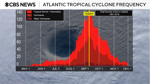
Looking at the Atlantic Ocean Basin, most tropical waves that eventually strengthen into tropical systems come off of the coast of Africa and travel across the warm ocean waters. But this year, Saharan dust has continued to move over the open waters, preventing the thunderstorm development that is needed to form a tropical cyclone.
Dust from Africa typically moves across the Atlantic every year, usually peaking from late June to the middle of August. However, high pressure in place over the North-Central Atlantic is allowing for fewer storms to develop in Northern Africa which creates the perfect conditions for dry dust to move through.
CBS News 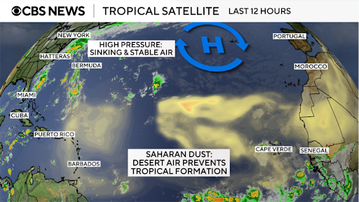
The planet is also in a cycle of what is known as “ENSO Neutral,” which means that neither El Nino nor La Nina are present. During El Nino, the winds near the equator weaken which allows warmer water to be pushed eastward. La Nina has the opposite effect of El Nino. During La Nina events, winds around the equator are stronger than usual, bringing colder water eastward.
When La Nina is present, fewer Eastern Pacific hurricanes occur and more Atlantic hurricanes form, and vice versa for El Nino periods. Since neither is currently present, we do not have a typical hurricane season.
According to the World Meteorological Organization, we are forecast to transition back into La Nina in the coming fall and winter months, and the current lack of hurricane activity signals the start of the transition period.
Hurricane season far from over
The National Oceanic and Atmospheric Administration, or NOAA, updated its forecast for the season back in August from its original analysis in May, predicting slightly fewer named storms. But it maintains that the Atlantic will see an above-average season.
Hurricane season is still far from over. As of Sept. 10, 60% of it is remaining.
NOAA predicts the Atlantic will see between 13 and 18 named storms this season, with as many as nine strengthening into hurricanes and as many as five growing into Category 5 storms, which are the strongest.
CBS News 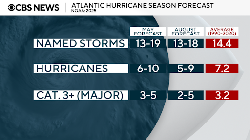
So far this year, six named tropical systems have developed in the Atlantic – Andrea, Barry, Chantal, Dexter, Erin and Fernand. Erin was the only one that made it to hurricane strength. In the U.S., only one system made landfall this season – the remnants of Chantal.
By this time last year, the same number of storms that we’ve seen this year – six – had formed. But three of them made landfall in the U.S.: Beryl, Debby and Francine.
After last year’s Sept. 10 statistical peak, other major hurricanes developed: Helene and Milton, later in the season. Milton made landfall in the U.S. and devastated parts of the Southeast.
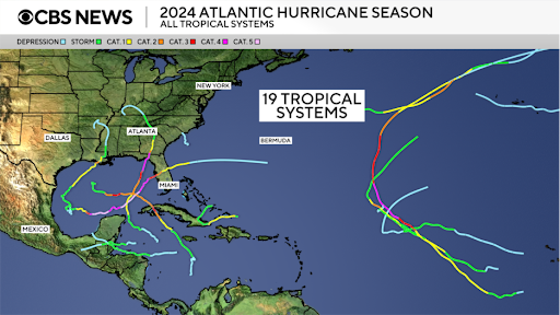
In total last year, 19 tropical systems formed in the Atlantic.
CBS News