

BBC News
Beach-goers from Florida to New England have been warned to beware of rip currents as Hurricane Erin churns off the US East Coast.
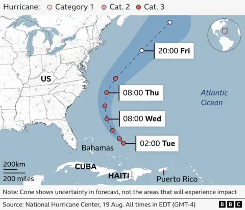
While the storm is not expected to make landfall, forecasters have warned of possible life-threatening flooding in North Carolina as Erin swirls northwards in the Atlantic Ocean. It swamped homes and roads in the US island territory of Puerto Rico.
Erin weakened to a category two storm on Tuesday, but is still packing maximum sustained winds of 105mph (168km/h), said the US National Hurricane Center (NHC).
Meteorologists say the hurricane is unusually big, with tropical storm winds spanning 230 miles from its core, and is forecast to get even bigger.
By Tuesday night, the centre of the storm was expected to pass to the east of the Bahamas.
On Wednesday and Thursday, the NHC said Erin would move between Bermuda and the US East Coast.
The Outer Banks, a string of barrier islands off North Carolina, are already bracing for heavy surf and high winds.
Mandatory evacuations of Hatteras and Ocracoke have been ordered amid fears that the main highway linking them to other islands could become impassable.
Officials warned that life-threatening inundation from coastal flooding was possible from Wednesday, with waves of 15ft (4.6m). Some roadways could be underwater for several days.
At least 60 people were rescued on Monday from rip currents – which flow away from the shore and can quickly pull people into the ocean – at Wrightsville Beach, North Carolina.
Map: Predicted path of Hurricane Erin

North Carolina Governor Josh Stein declared a state of emergency on Tuesday as he warned that residents along some parts of the coast might need to evacuate.
Further north, some beaches in Long Island, New York and in New Jersey have been placed off limits to swimmers, along with Rehoboth Beach, Delaware.
Erin, the first hurricane of the 2025 Atlantic season, “explosively deepened and intensified” on Saturday into a category five storm and has since been fluctuating in strength.
In Turks and Caicos, an overseas British territory, authorities suspended public services on the largest island while the storm was passing.
More than 150,000 people were also left without power in Puerto Rico after high winds damaged electricity lines, according to local energy company Luma.
But the firm said it had carried out emergency repairs and that by Sunday evening local time, 95% of its customers had working electricity.

